Tornado Imagery for Alabama and Georgia is Live

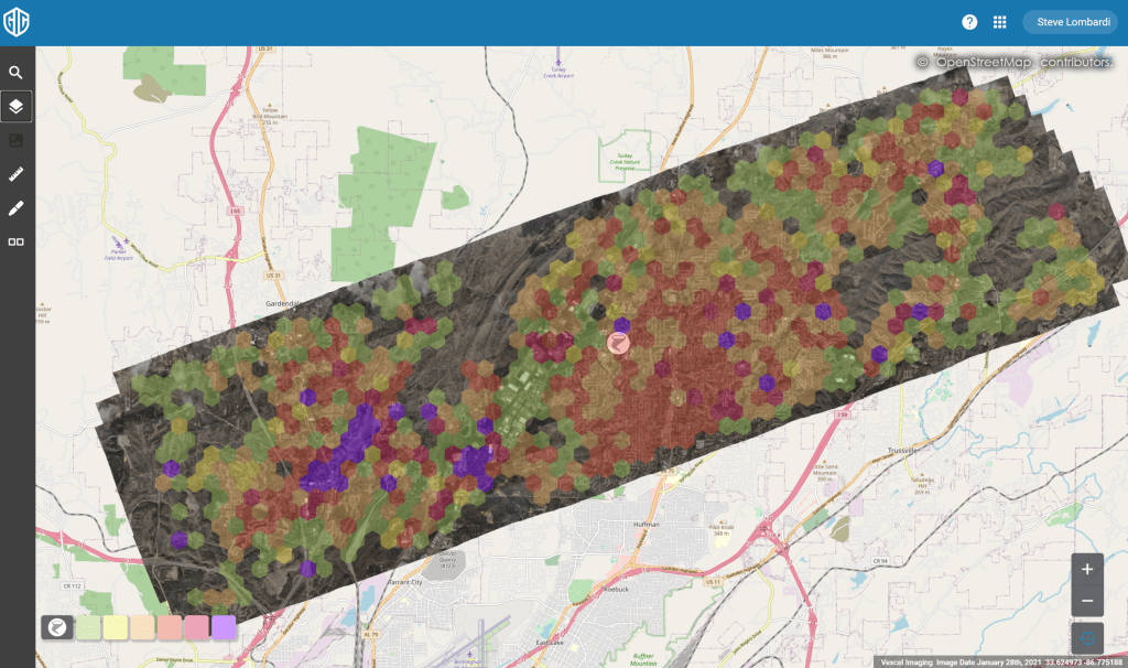
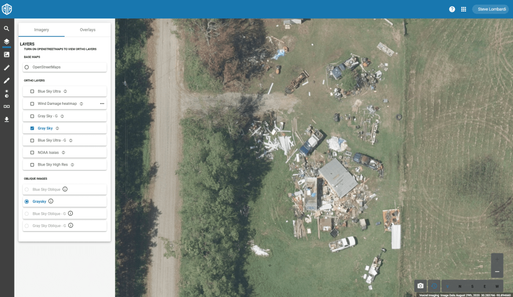
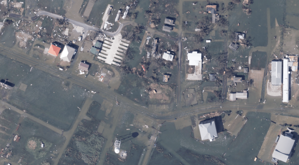
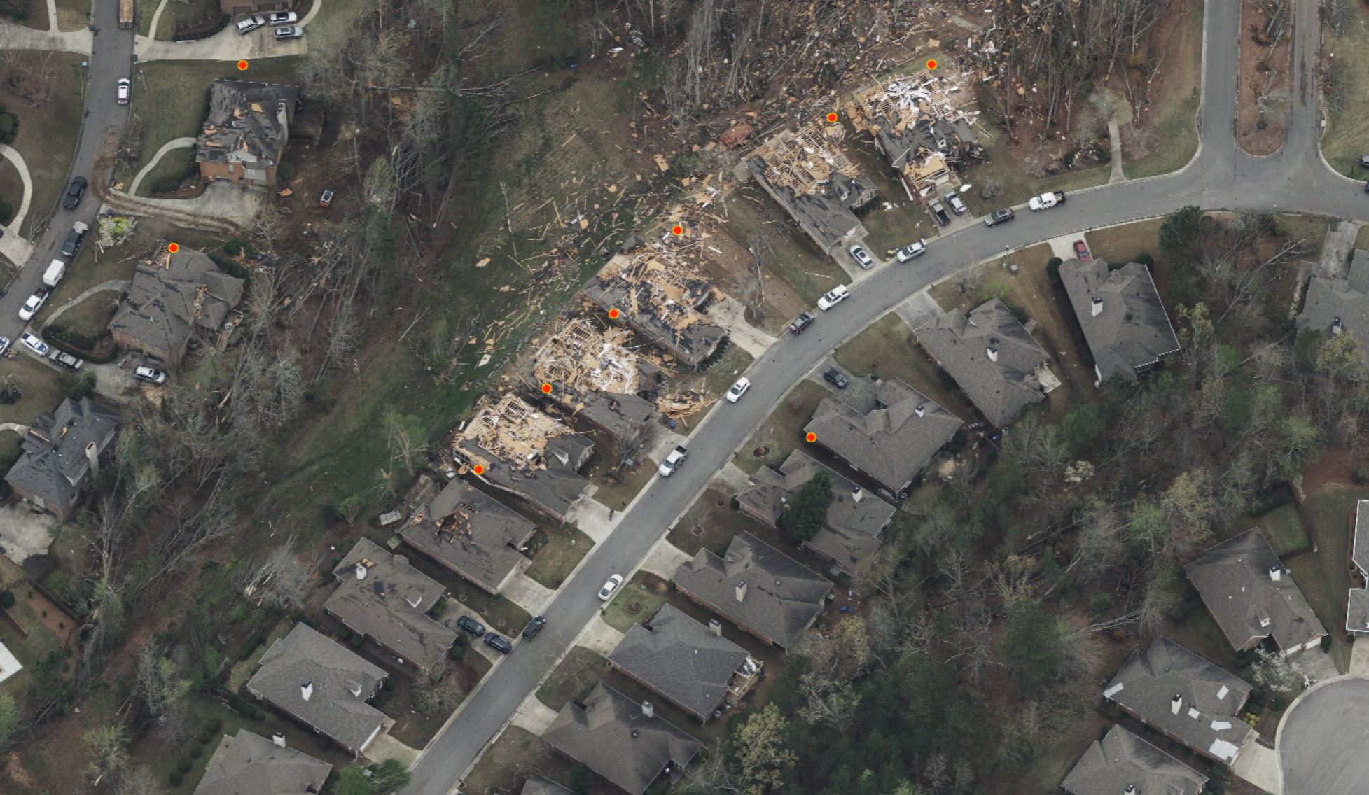
The GIC collected imagery over the tornados that struck Alabama and Georgia this week, and it is now published to our platform. Our web app also has a damage heat map for the regions we have flown that helps spot the worst hit areas. [read more on the heatmap here] You can also import your own property locations with the data import feature to visualize your properties of interest over the imagery and heat map [tutorial on data import]

Here are the regions we flew, with coverage maps below. If your organization needs access to our web app, drop an email to support@gic.org with your request.

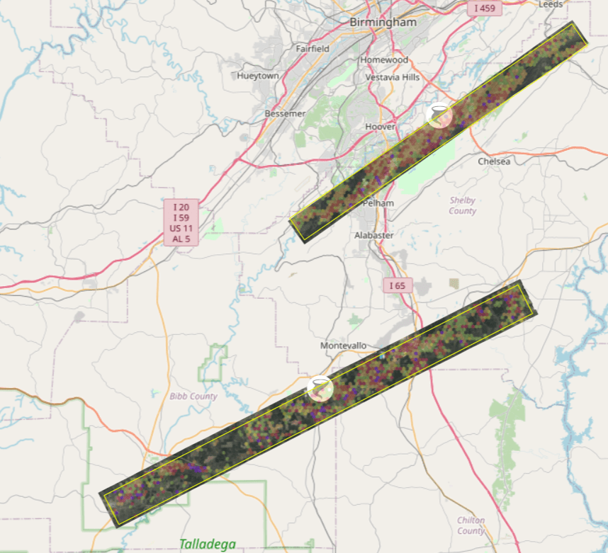
Brent/Centreville/Calera – Bibb, Chilton, and Shelby Counties, Alabama
An Eagle sensor was used for this tornado collecting nadir images. 

Helena/Pelham/Meadowbrook – Shelby County, Alabama
An Osprey sensor was used for this tornado collecting nadir and oblique images. 

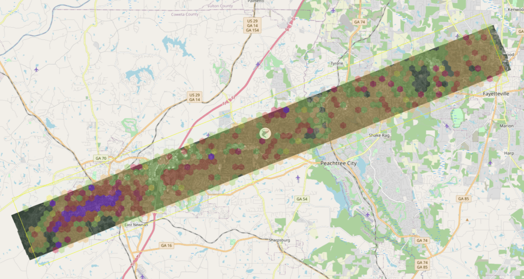
Newnan/Peachtree City – Coweta and Fayette Counties, Georgia
An Eagle sensor was used for this tornado collecting nadir images. 

Fultondale Alabama Tornado Imagery

Aerial imagery over the area hit by this weeks tornado in Alabama is live on our platform. Just over 250 square kilometers of imagery, including 45 degree oblique imagery, has been published covering the northern Birmingham suburb of Fultondale. A computer vision generated heat map of the damage is also available to all GIC members in our web app.

Below is a screengrab showing the area flown with the heat map turned on. If your organization needs access to our web app, drop an email to support@gic.org with your request.

GIC Responding to Western Fires

Historic wildfires continue to rage across California, Oregon and Washington, destroying thousands of homes and forcing tens of thousands to evacuate. Nationwide almost half of the large fires reported today have evacuation orders in place. GIC is activated to Level 1 – Full activation for this event.

Today we published imagery for our top 2 priorities of Alameda Drive and Obenchain Fires in Jackson County, Oregon. An attempt was made to collect over Holiday Farm and Lionshead/Santiam Fires in Oregon, but these areas were completely smoked in and for both safety of the crew as well as usability of the data, this attempt was abandoned, but is resuming today.

If you are a first responder or disaster response organization with need for access to this imagery, please reach out and we will get you setup promptly. email us at graysky@geointel.org. Above all else, please stay safe out there.

Hurricane Laura Summary

The GIC’s collection of Hurricane Laura imagery is complete with all data now available on our platform. In total, over 22,000 square kilometers of imagery were collected over three days beginning August 27th, utilizing 11 fixed wing aircraft in the effort. We had 9 planes in the air simultaneously at one point over the collection window, our largest catastrophe response since Hurricane Michael in October 2018.

At the GIC we understand how critical it is to have imagery in the hands of first responders and our Insurance industry customers quickly, which is why we feature a 24 hour response time; from when our planes land, we target having the imagery live on our platform within 24 hours. I’m very proud to say that our team delivered the first round of imagery in 14 hours!

So much work goes on behind the scenes to make the end product of the images like you see in this post possible; aircraft maintenance, camera tuning, flight planning, data transport and processing, platform readiness… not to mention the continuous battle with the weather and the challenges due to covid-19. I can only imagine that its not a fun ride piloting through the levels of turbulence at low altitude that our pilots deal with for an event like this. Kudos to the women and men working from end to end to deliver the pixels!

hey, look! a rainbow

Imagery available for this event includes 3,800 sq kilometers of 7.5cm resolution imagery over the hardest hit areas including Lake Charles, as well as 20,000 square km of 20 cm coverage. Much of the 7.5 cm area includes obliques as well as nadir.

Seeing through the smoke with Near-infrared imagery

We collected and published thousands of square kilometers of imagery over the California wildfires last week. As is often the case with wildfire imagery, some areas were still in heavy smoke cover when we flew. But because we collect in the near-infrared (NIR) band along with traditional RGB, there is still a great deal of utility in the imagery for understanding damage to structures in the affected areas. Further, with some dynamic range processing, it is also possible to see a lot of detail that would otherwise be lost in the smoke. Both of these image types are available as distinct layers in our Esri based web viewer.

The image featured at the top of this post is an example of NIR imagery providing a good amount of detail for a property that would otherwise be nearly completely occluded with smoke. The same property is shown here in its original state, side by side with the version after dynamic range processing.

Here is another example with a heavier layer of smoke, along with the same near-infrared image. Although the NiR image may not look like a traditional RGB image you are used to, the information gleaned from it can help first responders make faster, more informed decisions in planning and logistics.

Hurricane Laura Imagery

Our first round of collection for Hurricane Laura completed successfully yesterday, covering some of the hardest hit areas including Lake Charles, Beaumont and the gulf coast. Some samples are shown below at differing zoom levels; click each to view full screen and download.

We are continuing to collect today and invite GIC members, first responders, and state and local government to send their input to graysky@geointel.org

Monitoring Hurricane Laura

At 100 PM CDT, the eye of Hurricane Laura was located near latitude 27.3 North, longitude 92.5 West. Laura is moving toward the northwest near 16 mph (26 km/h). A gradual turn toward the north-northwest and north is expected later today and tonight. On the forecast track, Laura will approach the Upper Texas and southwest Louisiana coasts this evening and move inland within that area tonight. The center of Laura is forecast to move over northwestern Louisiana tomorrow, across Arkansas Thursday night, and over the mid-Mississippi Valley on Friday.

National Weather Service forecasts include “unsurvivable storm surge” with large and destructive waves will cause catastrophic damage from Sea Rim State Park, Texas, to Intracoastal City, Louisiana, including Calcasieu and Sabine Lakes. This surge could penetrate up to 30 miles inland from the immediate coastline. Only a few hours remain to protect life and property and all actions should be rushed to completion.

GIC maintains activation Level 2 – Partial Activation for California Wildfires and Hurricane Laura as well.

Initial areas of interest for imagery collection have been identified for the following areas:

  • Ultra-high resolution – Lake Charles, Louisiana
  • Ultra-high resolution – Beaumont, Texas
  • Ultra-high resolution – Port Arthur, Texas
  • Multiple resolution – coastal collect from Cameron, Louisiana to Galveston, Texas
  • High resolution – multi-jurisdictional regional collect

As this storm make landfall, GIC members are strongly encouraged to share specific requirements and areas of interest for collection with the Gray Sky team by emailing graysky@geointel.org.  

California Fires Update for August 25

The GIC remains activated to Level 2 – Partial Activation for this event, with aerial imaging continuing today over Monterey County. Here are the details for todays update:

CZU Complex – Santa Cruz and San Mateo counties – imagery collected yesterday now published to GIC platforms

Walbridge Fire – Sonoma County – collected yesterday; imagery is shipping, will be processed late tonight, and available tomorrow morning

Carmel/River Fires – Monterey County –  targeted for collection today

All imagery collected so far for this catastrophe is nadir 10cm resolution acquired with UltraCam Falcon.

Areas of Interest with Completed Flight Lines

California Fires Update for August 23

Firefighters continue to battle blazes across central and northern California. Two of the fires burning in California now rank among the top three ever recorded in the state. More than 1,500 square miles have burned. Over 1,000 homes have been destroyed. A Red Flag Warning is in effect for much of the hardest hit areas through Monday for dry thunderstorms.

More imagery from the Fires is being published today as we continue to fly and collect. We understand how important timely access to this imagery is. Please reach out if you need access.

The cell phone photos below taken by the crew collecting the imagery are pretty telling. That’s some dense smoke right there, along with the dramatic shot of the fires burning off the wing 2000 feet down.